In August 2001, Sundsvall was adversely impacted by floods in the Selångersån river, which flows through the city, and in Sidsjön south of the city, there was a risk that a dam might burst. The Municipality has since reinforced the Sidsjö Dam and established a forecasting and monitoring system that provides the ability to measure flows and make flow forecasts for the immediate future.

As a consequence of the unusually heavy rainfall in and around Sundsvall, the river was flooded and the Sidsjö dam was subjected to severe stress from the heavy loads. The emergency services managed to reinforce the dam temporarily and prevent it from bursting. They also protected vulnerable houses and buildings along the Selångersån river using provisional stopbanks and mobile water pumps. In November of the same year, the dam was reinforced with 6.2 tonnes of concrete. In addition, the floodgates were removed and nowadays the dam is now adjustable.
So as to reduce the risk of flooding in the future, Sundsvall Municipality retained a consultant to develop a flow and forecasting model, for the section between Selångersfjärden and the Selångersån river’s outlet to Sundsvallsfjärden.
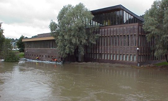
The Sporthallsbadet pool is one of the most vulnerable points along Selångersån. Here the emergency services are working with temporary embankments used as emergency makeshift levees in order to deal with the flooding in the autumn of 2001.
Flows in the rivers and rising sea levels
Calculations show that the Selångersån river is affected by both sea levels and the flows. One effect of climate change is that we are seeing a rise in sea levels. For the immediate future, rising sea levels do not present an increased threat of flooding from the Selångersån river. This is due to that the land uplift in Sundsvall occurs at a faster pace than the amount the sea is expected to rise, and it is not until the next century that the rising sea levels is expected to be faster than the pace of the land uplift.
How the system works
The model created for the Selångersån river’s flows can generate, by using previous measurements, an anticipated flow for the next ten days. The data that is used include flow data, riverbed data, sea level data, terrain data and weather forecasts.
The Office of City Planning in Sundsvall Municipality monitors the projected flows and issues warning alerts in the event critically high levels in the river are anticipated. they have learned from experience how to interpret what a certain flow corresponds to in terms of the water level in the river. The Streets Department, the emergency services in Medelpad and the Municipality’s emergency preparedness unit also have access to the forecast website.
The second element of the system is measuring the flows. Measuring equipment has been placed in the water in four different locations. The measurement values from these locations are used to verify the forecast values provided by the model, a form of “quality control,” if one can say.
Challenges and Experiences
It takes experience in order to be able to interpret which water levels in the river correspond to the different flows. In order to make the system robust, training programmes are conducted for staff in the departments in the Municipality that have access to the forecast monitoring, so that more people have the ability to identify critical levels in the river.
The forecasting system opens up the possibility of advance warning and calling attention to critical levels in the Selångersån river. This establishes a sense of security, and provides the possibility to take preventive measures at an early stage and to organise the sharing work responsibilities. It is also less costly to work preventively than to deal with flood-related damage after the fact. A cost of SEK 350,000 was incurred for the development of the model and for establishing the monitoring system. The operational cost amounts to SEK 5,200/year and data collection approx. SEK 30,000/year.
More examples of climate adaptation
This is one of many examples of climate adaptation. There are more in the collection of ideas being built up by the Swedish National Knowledge Centre for Climate Change Adaptation at the Swedish Meteorological and Hydrological Institute (SMHI). The collection of examples has the aim of sharing experiences and providing ideas to everyone who works with climate adaptation. Examples describe concrete measures and challenges in several subject areas. They show how different actors have worked to adapt their activities to the climate changes that are already being noticed today and those that we cannot prevent in the future.